At 2,036 metres, Dalhousie sits where the clouds have nowhere else to go. The town spreads across five hills — Kathlog, Potreyn, Tehra, Bakrota, and Bhangora — rising high above the Chamba valley. Established in 1854 by Lord Dalhousie, the Governor-General of India, as a summer sanatorium for the British administration, it retains a quiet, Victorian footprint. In November, when the summer crowds have cleared and the winter snows are still a month away, the town belongs to the quiet walker and the camera.
There is an unhurried, almost meditative quality to the air here. As you walk the winding mountain roads flanked by towering Himalayan deodars, the scent of pine is thick, and the quiet is broken only by the wind or the distant chime of a church bell. For a photographer, this late autumn month is a season of fleeting light, drifting mists, and clean lines.
.jpg)
A British Summer Escape That Outlasted an Empire
Dalhousie was born of necessity. In the mid-19th century, the British Punjab administration sought a high-altitude refuge where soldiers could escape the summer heat of the plains. They negotiated with the Raja of Chamba for five wooded hills, and by the late 1850s, a new hill station had emerged. Stone cottages, wide-verandaed bungalows, and churches like St. John’s (1863) and St. Francis (1894) were constructed, giving the town a distinctly Victorian character.
Unlike other crowded hill stations in India, Dalhousie has managed to preserve its layout. The buildings do not crowd the slopes; instead, they sit quietly between the trees, as if apologizing for their presence. Walking past these colonial facades is like walking through a landscape painting from another century.
.jpg)
- 2,036 m (6,680 ft) — spread across five distinct hills
- Founded in 1854 by Lord Dalhousie, Governor-General of India
- Located in the Chamba District of Himachal Pradesh
- Only 80 km from Pathankot, the nearest railway station
- Features the famous sun-facing Garam Sadak walk
- Winter temperatures dip to -4°C with heavy snowfall
Tagore, Netaji & the Mountain's Memory
There is a literary and historical residue to these roads. In 1873, a twelve-year-old Rabindranath Tagore arrived in Dalhousie with his father, Debendranath. Staying at the Snowdon bungalow, the young Tagore was exposed to the mountains for the first time. He would later write in his autobiography how those early morning walks under the deodars and the view of the snow-covered peaks first awoke the poet in him.
Decades later, in 1937, the freedom fighter Subhash Chandra Bose spent several months in Dalhousie to recover from an illness. He stayed at Kynance, a cottage on Bakrota Hill, and regularly drank water from a natural spring that is now named Subhash Baoli in his honor. The town has always been a sanctuary for restless minds seeking healing and inspiration.
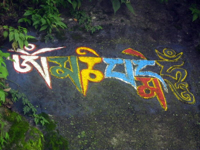
The Forest & the Prayers on Stone
As you walk further away from the main chowks, the houses thin out, and the forest takes over. Along the paths, particularly around the Bakrota loop, Tibetan Buddhist prayer flags flutter in the wind, strung between blue pines and oaks. On the rocky embankments, you will find stones meticulously painted and carved with Tibetan scriptures. Following the Dalai Lama's exile in 1959, a large community of Tibetan refugees settled in the region, bringing their faith to these Himalayan slopes, leaving a sacred imprint on the landscape.
.jpg)
Gandhi Chowk & the Bazaar the Mist Keeps
Gandhi Chowk is the commercial pulse of Dalhousie, a central intersection where locals and visitors meet. But in November, when the sun dips, the square takes on a mystical quality. A cold, thick mist rises from the valley below, spilling over the ridges and wrapping the shops in white. The corrugated green and yellow tin roofs of the bazaar shops shine in the damp air, and the streetlights turn the drifting fog into a warm, glowing amber canvas.
.jpg)
The Garam Sadak at Twilight
The town's layout is centered around two famous walking paths that form a figure-eight loop: Garam Sadak (Warm Road) and Thandi Sadak (Cold Road). Garam Sadak, built on the south-facing slope of the hill, receives direct sunlight throughout the day, keeping it warm even in the depths of winter. At dusk, as the sky transitions to a deep electric blue, the streetlights on Garam Sadak cast long, warm reflections on the empty road, silhouetting the massive deodars against the twilight.
.jpg)
"The mountains are not stadiums where I satisfy ambition. They are cathedrals where I practice my religion."
November Wildflowers: The Gardens Fight Back
Even as the cold sets in, Dalhousie refuses to surrender all its color. In the small gardens of old bungalows and along the damp stone retaining walls, nasturtiums and cosmos continue to bloom. Their bright orange and purple petals are often coated with droplets from a passing shower or afternoon mist, a tiny, vibrant defiance against the oncoming winter.
.jpg)
After the Shops Close
By 6 PM, the temperature drops sharply. The shopkeepers of the bazaar begin shuttering their wooden doors, packing away their goods, and heading home. The roads empty out, leaving only the safety barriers and the silhouettes of the hills. A single car rounds a bend, its headlights slicing through the darkness, leaving a warm red streak of taillights in the camera's shutter. Dalhousie returns to the mountains.
.jpg)